A segment of the Schuylkill River Trail that has beenclosed since October because of a sinkhole has been repaired, and reopened just in time for Christmas Eve.
Joe Syrnick, executive director of the nonprofit Schuylkill River Development Corp. (SRDC), said Wednesday afternoon that repairs finished earlier in the day.
But, he said Wednesday, the weather cooperated enough this week that a crew was able to complete the work over a few days, “as a holiday present for our trail users.”
This week, the hole was filled and paved. It reopened about 1:30 p.m. Wednesday after the paving had cooled.
“It’s open and people are already using it,” Syrnick said. “People are happy.”
Some cleanup is still needed around that area, he noted, and fencing needs to be removed. That should be finished by Friday or Monday, Syrnick said.
The Schuylkill River Trail is now open between JFK Boulevard and Race Street in Philadelphia, Pa., on Wednesday, Dec. 24, 2025.
The sinkhole occurred between Race Street and JFK Boulevard, just north of the SEPTA Bridge, after it formed beneath the asphalt. The trail runs along Schuylkill Banks, a portion of the Schuylkill River Trail.
The SRDC works with the city to revitalize the Schuylkill corridor from the Fairmount Dam to the Delaware River, the eight-mile stretch known as Schuylkill Banks.
The sinkhole repair presented a problem that stemmed from a steel bulkhead that was built for the trail in 1995. The bulkhead helped extend land farther into the river and create more parkland.
But gaps developed in a seal between the bulkhead and concrete sewer infrastructure. Those gaps allowed soil to seep away with the tide, eventually washing away enough to create a sizable hole.
Syrnick said the SRDC and the Philadelphia Streets, Parks and Rec, and Water Departments worked together to come up with a solution.
So workers had to seal the gaps.
The weather was clear enough this week that crews were able to pour concrete to fill part of the hole and backfill it before paving it Wednesday.
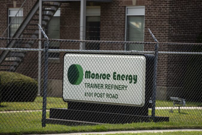
Hundreds of thousands of gallons of gasoline leaked over a period of months at a Monroe Energy petroleum tank farm in Aston, Delaware County, according to company and state officials.
The leak was first identifiedin August, and it was traced in December to a one-quarter-inch hole in the bottom of a tank. It totaled about 9,000 barrels, or 378,000 gallons, at the Chelsea Pipeline Station and Tank Farm.
The facility contains 12 aboveground tanks and is operated by MIPC LLC, a subsidiary of Monroe Energy. It is about five miles north of the company’s Delaware River refinery, which is in Trainer, Delaware County.
The Pennsylvania Department of Environmental Protection (DEP) said Tuesday it has ordered that some nearby homes with wells within 1,000 feet of the facility’s western border be provided bottled water if requested. And it ordered that the company “begin an interim cleanup plan and thorough investigation.”
MIPC said in a statement that it had notified local, state, and federal authorities. It said that on Dec. 13 crews determined that the source of the spill was traced to one tank.
It further said that an EPA-approved lab it had contracted tested residential wells, “and all results have shown no petroleum related compounds.”
MIPC said that the tanks are routinely inspected and that the company is conducting daily testing of monitoring wells along its fence line and inspecting local waterways.
“No further releases have been found,” the statement said.
“We sincerely apologize for any concern that this may be causing our neighbors,” the statement continued. “MIPC is committed to ensuring that the entire affected area is remediated and returned to its original condition.”
Adam Gattuso, a Monroe Energy spokesperson, said the leak is “considered one cumulative event, over the course of several months.”
He said that if people are within 1,000 feet of the facility’s western border and have a potable groundwater well and would like bottled water delivered to their home, the company would do so within 24 hours. He said the company will soon mail letters to those residents.
DEP Secretary Jessica Shirley said in a statement Tuesday that “swift action by the company is necessary to fully investigate the extent of damage and address the community’s needs.”
According to the DEP order, the first report of an issue came over the summer at the facility, where a series of aboveground tanks are part of a pipeline network.
The company notified county officials on Aug. 19 of hydrocarbons found in a storm sewer at the facility. It said no leaks were found, but there was “sheening” on the water.
MIPC did not know the source of the gasoline on the water and said it would continue investigating.
On Sept. 3, the company notified officials it “had discovered water with petroleum odors discharging from a concrete drainage pipe” leaking unleaded gasoline at a rate of five gallons per minute.
The DEP ordered MIPC to treat and discharge the contaminated water.
The agency said the company’s investigations from September through November found no signs of additional leaking.
The DEP had not heard from MIPC regarding any leaks until Dec. 5, when the company reported to the U.S. Environmental Protection Agency’s National Response Center “that the amount of gasoline released may be significant and was impacting soil and groundwater.”
It notified officials that the source of the leak had been found in the tank.
As a result, the DEP has ordered MIPC, in addition to supplying bottled water, to identify residents with private wells within 1,000 feet of the facility that spans Bethel, Upper Chichester, and Aston Townships.
And it ordered the companyto sample private wells for petroleum, submit a plan to detect potential vapors near homes, schedule environmental investigations, submit a remedial plan, and communicate with officials and the public.
As of yet, the DEP has not cited any violations or issued any fines.
Editor’s Note: This story has been updated to include additional information about water bottle availability for residents.
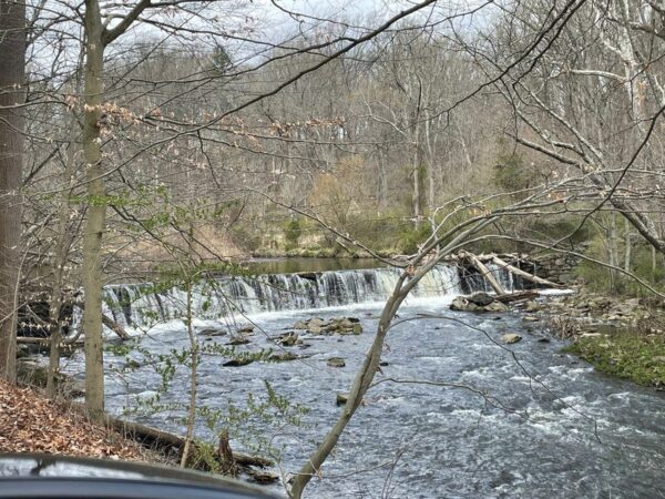
The lower Schuylkill winds 36 miles from Phoenixville in Chester County to its tidal meeting point with the Delaware River at Philadelphia’s Navy Yard, sheltering more than 40 species of fish along the way.
In Center City, the river doubles as a striking urban backdrop, bordered by a trail that can draw thousands of hikers and cyclists daily.
This year, the waterway is vying for the title of Pennsylvania’s River of the Year, an annual competition spotlighting the state’s most significant waterways.
Online voting, which began Dec. 9, runs through Jan. 16, giving Pennsylvanians the chance to select the 2026 winner from three contenders: Chillisquaque Creek, the Conestoga River, and the lower Schuylkill in the Philadelphia region.
The River of the Year program is administered by the Pennsylvania Organization for Watersheds and Rivers, with funding from the Pennsylvania Department of Conservation and Natural Resources (DCNR).
The contest is meant to draw public attention to rivers and their environmental importance. The winning river’s nominating organization receives a $15,000 DCNR grant to fund yearlong celebrations, including paddling events and community activities. The DCNR produces a commemorative poster in honor of the river.
Jackson Quitel, river programs coordinator for the nonprofit LandHealth Institute, said his organization nominated the Schuylkill along with a plan to educate the public “in the many wonders in this unique body of water.”
“While the Schuylkill River is widely known, not many people are aware of the immense recreational activities and ecological wonders that are present on the river today,” Quitel said.
The LandHealth Institute helps increase awareness of the river through guided walks, fishing, and kayaking, taking more than 500 people out on the water in 2025. If the Schuylkill wins, Quitel said, it would allow the group to double its reach.
Joe Syrnick, executive director of the nonprofit Schuylkill Development Corp., which helped develop the Schuylkill Banks trail along the river, called the river “a great asset to the region.”
“It would be nice to see it get the recognition it deserves,” Syrnick said.
Once a vital waterway for the Lenni-Lenape, the river later endured severe pollution from upstream coal mining and industrial waste, eventually rebounding through years of efforts, including the protections of the federal Clean Water Act.
The Schuylkill became the nation’s first municipal‑scale water system through Fairmount Water Works and continues to provide drinking water to 1.5 million people through two intakes along its banks.
The Schuylkill River Trail, a continuous corridor running alongside most of the lower Schuylkill, has broadened access to the river’s views for residents, giving them more insight into a river many were once cut off from.
Most recently, the Schuylkill Banks section in Center City debuted a new $48 million cable‑stayed, pedestrian‑only bridge, anchoring a trail extension known as the Christian to Crescent Trail Connector. The 2,800‑foot segment delivers sweeping, unobstructed views of the river.
The DCNR describes the lower Schuylkill as an “urban oasis surrounded by bustling roads and a backdrop of a gorgeous skyline.”
Pennsylvania has 25 rivers. Of those, six are federally designated as wild and scenic and 13 are state-designated scenic rivers.
Contest nominees can also include tributaries within river watersheds. For example, Chillisquaque Creek is a 20 mile-long tributary of the Susquehanna River’s west branch. It flows through Northumberland and Montour Counties.
The Conestoga, meanwhile, feeds Chesapeake Bay.
Overall, Pennsylvania has 85,000 miles of waterways, which is the highest stream density in the continental United States.
A sinkhole that shut down a segment of the popular Schuylkill Banks trail in Center City in October remains unrepaired, though work could begin early in the new year — if weather allows.
Joe Syrnick, executive director of the Schuylkill River Development Corp. (SRDC), a nonprofit that has driven the revitalization of the section of the Schuylkill River Trail known as Schuylkill Banks, said he expects repairs to start soon, though he could not offer a firm timeline.
The trail has been closed between Race Street and JFK Boulevard, just north of the SEPTA Bridge, after a “chasm”-sized void opened beneath the asphalt.
According to Syrnick, the city Streets Department will handle the repairs. The hole presented a challenge, Syrnick said, because of its size and position next to the river.
A representative for the Streets Department could not be reached Monday for comment.
Syrnick explained that the sinkhole has been far from a simple fix.
“It took a while to figure out the problem and develop a solution,” Syrnick said. “There were several dye tests and a drone flight into the sewer channel and visual observation from topside.”
The problem stems from a steel bulkhead that was built for the trail in 1995 to extend land farther into the river and create more parkland, he said.
Gaps developed in a seal between the bulkhead and concrete sewer infrastructure. It’s unclear, Syrnick said, whether those gaps occurred at the start or developed over time.
Regardless, the gaps allowed soil to seep away as the tide ebbs. Over the decades, enough soil was washed away “to create a sizable hole,” he said.
The gaps had to be sealed before anything else could be done.
So the job became more than just filling a hole. Recent progress has been halted by weather, especially recent cold and snow.
“City workers need two to three days of moderate temperatures and no rain to pour the concrete and let it cure,“ Syrnick said. ”After that, the hole has to be backfilled and paved.”
However, holidays also present a staffing issue, Syrnick said.
“In a perfect world,” he said, “the trail would be open by New Year’s or a short time after.”
With First Day hikes surging in popularity, Pennsylvania and New Jersey are rolling out a full slate of outings to welcome 2026 — from daybreak rambles to sunset treks, and nearly every hour in between for those easing into the new year.
Many of the guided hikes require advance registration and fill quickly.
The Jan. 1 hikes are offered through the Pennsylvania Department of Conservation and Natural Resources (DCNR) and the New Jersey Department of Environmental Protection (DEP). Some are guided by rangers, others by volunteers.
Another option: Join the Friends of Ridley Creek State Park in Media, Delaware County, for a 3.5-mile loop featuring creek views and a stop at historic hilltop Russell Cemetery.
Or, for a spectacular bird’s-eye view of the Pinelands at daybreak, you can tackle a 2.5-mile round trip, starting at 6 a.m., to Apple Pie Hill in Wharton State Forest, where hikers climb the 79 steps of the fire tower at sunrise. The only drawback: The hike has become so popular that the DEP holds a lottery at 1 p.m. on Dec. 31 to select participants.
Apple Pie Hill Tower offers a dramatic view of the Pinelands.
First Day Hikes began in Massachusetts in 1992, and went nationwide in 2012 under an effort by the National Association of State Park Directors.
Ian Kindle, environmental education regional program coordinator for DCNR’s Bureau of State Parks, said the hikes in Pennsylvania started not long after that. But, he said, they have become increasingly popular since the pandemic, when many people took to the outdoors.
“I think people have really taken to the idea of making getting outdoors on the first day of the year a tradition.” Kindle said. “I know that some of the first ones I led at Delaware Canal State Park, we could have 100, 150, and upward of 200 people, which is a challenge to lead.”
Last New Year’s Day, 2,488 people — and 224 dogs — participatedin Pennsylvania. They gathered for 74 hikes at 47 state parks and one state forest, accumulating 6,478 miles.
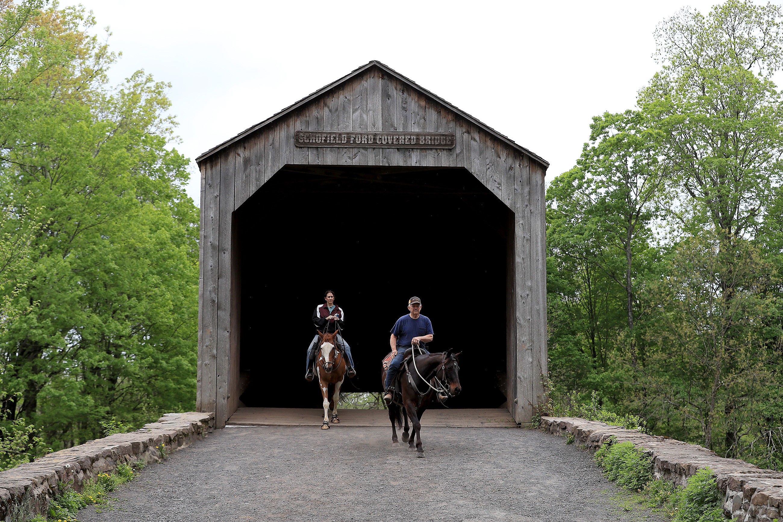
Cheryl and Gary Moore, of Bucks County, ride their horses over the Schofield Ford covered bridge in Tyler State Park in Newtown, Bucks County in this 2021 file photo.
The two most attended hikes were at Beltzville State Park in Carbon County in the Poconos (175 people) and Tyler State Park in Bucks County (170 people).
This year, DCNR has organized 60 free guided hikes in 49 state parks and three forest districts, choosing to make the walks more focused.
Kindle said an “almost full moon” hike is set for Delaware Canal State Park in Yardley, Bucks County, at 4 p.m. He noted a two-mile hike around Militia Hill at Fort Washington State Park in Montgomery County.
The hikes include: walks at 10 a.m., noon, and 2 p.m. through historic Revolutionary-era Batsto Village in Wharton State Forest; a more rigorous six-mile hike at Brendan T. Byrne State Forest on the Cranberry Trail that includes Pinelands cedar swamps and Pakim Pond; and a two-mile hike at Washington Crossing State Park in Mercer County where you can learn about the famed feat by the Continental Army that routed the Hessians at Trenton.
Tourists arriving in Philadelphia next year may find it easier and far more inviting to stroll through what is now a tucked-away stretch of Old City.
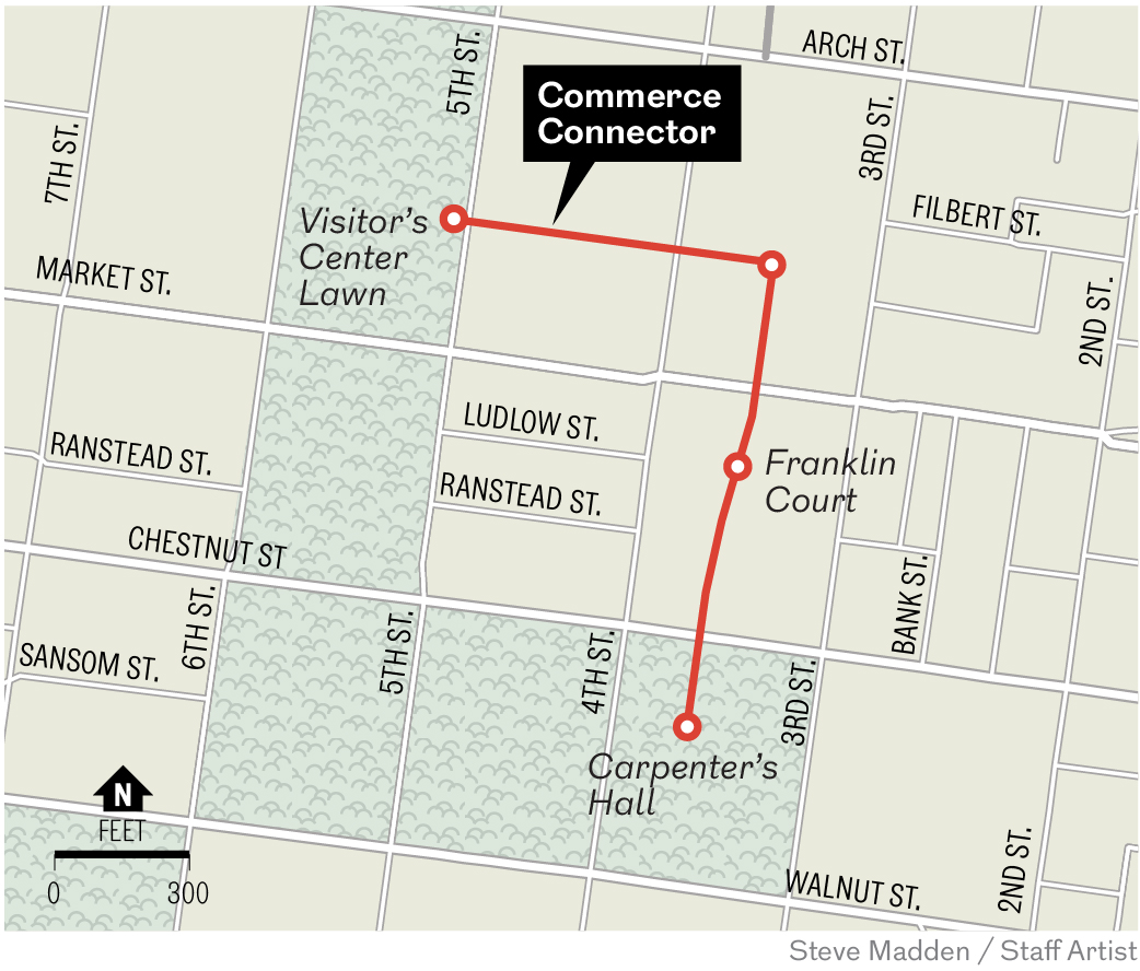
On Wednesday, the city launched construction on what officials call the Commerce Connector, a pedestrian path designed to guide visitors from the Independence Visitor Center to Carpenters Hall along a brick‑lined walkway adorned with seating and ornamental plantings, while bypassing a congested area.
The city has allocated $2.7 million toward the project.
The project is spearheaded by the nonprofit Independence Historical Trust in collaboration with the city; Old City Green, a neighborhood beautification group; and Old City District, a business support organization.
Bill Marrazzo, chair of Independence Historical Trust, called the connector “an important step forward.”
“The Commerce Connector enhances the visitor journey between some of Philadelphia’s most treasured sites while also improving everyday walkability for residents and workers,” he said in a statement.
A rendering of a new connector pathway planned in Old City.
The bigger picture
The connector is part of a larger effort by the city and nonprofits, led by Independence Historical Trust, to craft a broader vision for the city’s historical area. Some will be complete by the Semiquincentennial, and others might not.
That vision, which could take $100 million to implement, calls for more walkable and bike-friendly streets, new plazas, additional green spaces, and easier navigation to cultivate a sense of cohesiveness they say is lacking.
The Historical Philadelphia Vision Framework plan aims to create ways for people to “wayfind” easy-to-follow, less car-centric routes through Independence National Historical Park, Old City, and other historic or local neighborhoods.
The current redo of Market Street in Old City, now under construction, is part of that. It will include a new Tamanend Plaza at Second and Market Streets, and a “road diet” to accommodate bike lanes. Workers were busy Thursday putting down blocks for the new plaza.
Work is also underway by the National Park Service at the Declaration House at Seventh and Market Streets, where Thomas Jefferson stayed while he wrote the famed document, and at the Benjamin Franklin Museum off Chestnut Street, both part of Independence National Historical Park. Also, the 25,000-square-foot, Greek Revival-style First Bank of the United States is undergoing $27 million in work, timed to reopen as a new park attraction for the Semiquincentennial.
What’s the route?
The roughly 2,000-foot-long Commerce Street foot path will lead travelers from the edge of the visitor center’s lawn at Fifth Street, east across Market Street, and onto Commerce Street, now an unmarked alley that runs parallel to Market Street. From there, they will continue east before turning right onto another alley, which leads to Market Street.
A 2024 view of Commerce Street, an alley that starts on Fifth Street, midway between Arch and Market Streets. Commerce Street would become a way to connect Independence Visitor Center with Carpenters Hall under a plan led by Independence Historical Trust.
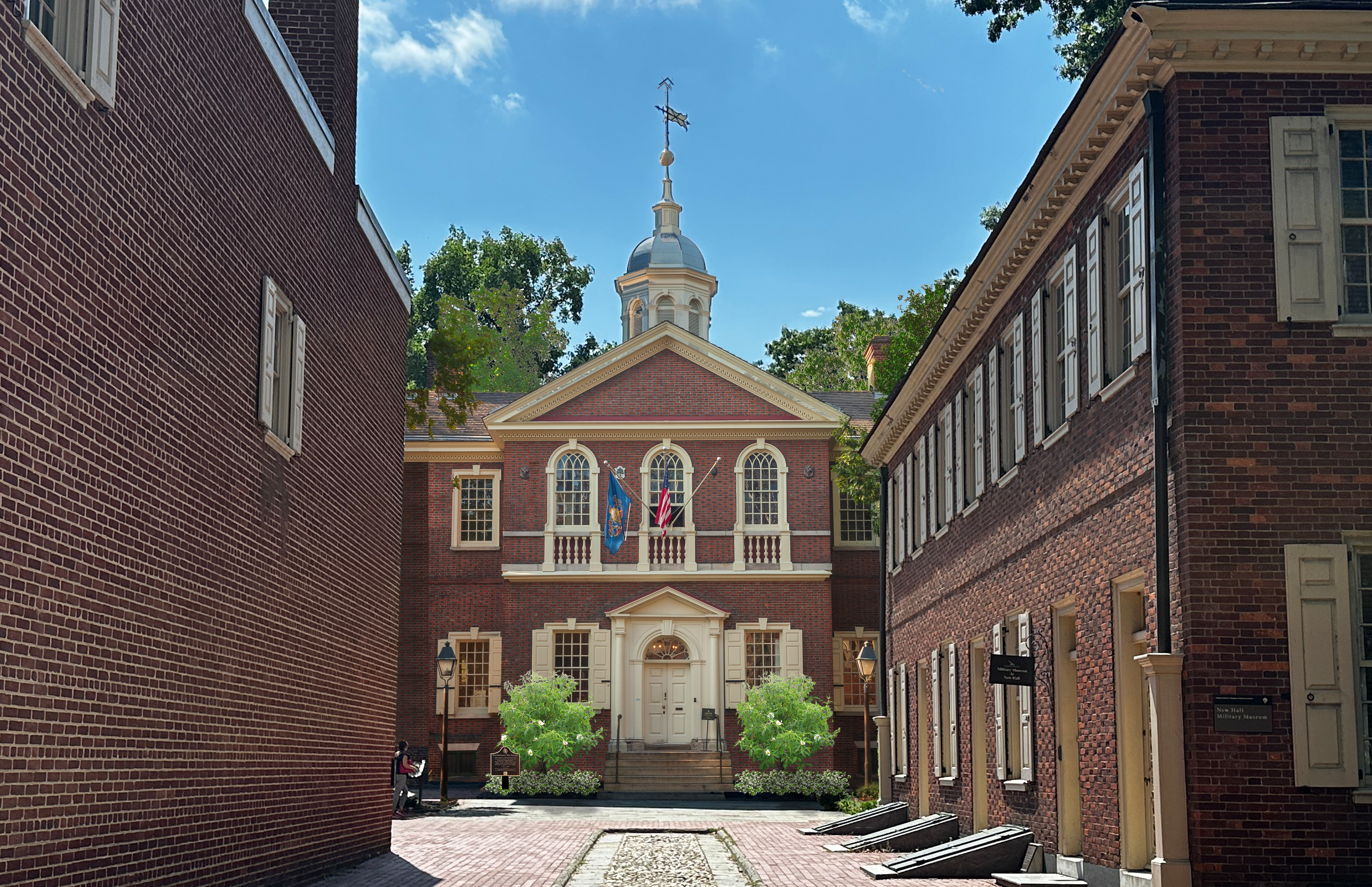
After crossing Market, they will cut through Franklin Court, cross Chestnut Street, and arrive at Carpenters Hall.
Once at the hall, visitors can branch out into the wider Independence National Historical Park and other notable areas.
Officials emphasize that the connector will deliver a mostly traffic‑free passage to Carpenters Hall in time for an anticipated surge in tourism tied to the 250th anniversary of the Declaration of Independence. Carpenters Hall was the site of the first Continental Congress in 1774.
A rendering of a new connector walking path being built in Old City.Commerce Connector pedestrian route through Old City.
Other enhancements
Officials say existing paving, benches, lighting, and plantings are all in poor condition.
The redesigned corridor will get new furnishings, better lighting for security, ornamental trees and bushes, and other enhancements to make it more inviting. It would include a “gathering area” and new entrances.
To slow traffic for pedestrians, a speed bump mid-block on Fifth Street would connect Independence Visitor Center and the alley. Another mid-block bump on Fourth Street would help pedestrians cross Market Street to Franklin Court.
Fourth Street would get a bike lane.
New signs would note area history.
The path would also help connect people to Christ Church Burial Ground, Commodore Uriah Phillips Levy Park, and the Faith and Liberty Discovery Center.
Construction is expected to be complete before July Fourth, ahead of the nation’s Semiquincentennial.
Carpenters Hall.
“The Commerce Connector reflects our commitment to making Old City safer and easier to navigate for everyone,” said City Councilmember Mark Squilla, who helped secure funding.
Job Itzkowitz, executive director of Old City District, said the connector “strengthens the backbone of Old City by transforming an underused passageway into a vibrant, welcoming public space” that will make it easier for residents and tourists to move between iconic city sites.
Old City Green launched the early planning efforts for the corridor and will continue to help maintain the path.
“By introducing new plantings, shade, and thoughtfully designed landscape elements, we’re creating a greener and more accessible environment for everyone who walks through this historic neighborhood,” said Joe Schiavo, vice president of Old City Green.
Residential waste, construction and demolition debris, as well as sewage treatment plant sludge, were dumped for decades at the 30-acre Boyertown Sanitary Landfill in northern Montgomery County until it was capped in 1987.
As state and federal officials mull whether to add the landfill to the national Superfund list, a well used by nearby Gilbertsville Elementary School has tested positive for human-made polyfluoroalkyl substances, known as PFAS.
The school is about 3,000 feet from the landfill property border and is within the Boyertown Area School District. Minister Creek passes through the property, and two residential neighborhoods are nearby.
Scott Davidheiser, the district’s superintendent, sent a letter to staff and students’ families Monday alerting them to the test results, which were made known during a Pennsylvania Department of Environmental Protection (DEP) public information session on the landfill on Dec. 10.
Gilbertsville Elementary tested at an annual average of 6.7 parts per trillion (ppt) for PFAS. That falls under acceptable limits by current state standards of 14 ppt.
However, it would exceed federal maximum contaminant level standards of 4 ppt set to go into effect in 2031 if not addressed.
Davidheiser’s letter said the district “remains committed to safety in all areas, including water safety.” The districthas hired Suburban Water Technology Inc. to develop a water safety planto lower annual average PFAS levels to within federal standards.
District officials plan in January to discuss a plan to lower the levels.
<iframe title="Boyertown Sanitary Landfill and PFAS contamination" aria-label="Locator map" id="datawrapper-chart-1kgam" src="https://datawrapper.dwcdn.net/1kgam/1/" scrolling="no" frameborder="0" style="width: 0; min-width: 100% !important; border: none;" height="581" data-window.addEventListener(“message”,function(a){if(void 0!==a.data[“datawrapper-height”]){var e=document.querySelectorAll(“iframe”);for(var t in a.data[“datawrapper-height”])for(var r,i=0;r=e[i];i++)if(r.contentWindow===a.source){var d=a.data[“datawrapper-height”][t]+”px”;r.style.height=d}}});
What are PFAS?
PFAS are a group of chemicals manufactured by industry for use in consumer products since the 1940s. There are thousands of different PFAS, some of which have been more widely used and studied than others.
Exposure to them hasbeen shown to impact the health of humans and lab animals, but the extent is still being studied.
Standards for maximum acceptable levels of the compounds in drinking water have created confusion in recent years.
The EPA was slow to set standards, so states began setting their own. Pennsylvania set different levels to start in 2024 for various types of PFAS:14 ppt forperfluorooctanoic acid (PFOA) and 18 ppt for perfluorooctane sulfonic acid (PFOS).
However, the EPA, under the Biden administration, then set the first federal standards, which would supersede state standards. The rule said that PFOA and PFOS can’t exceed 4 ppt. And, it set standards for other compounds within the PFAS family. The regulations were set to go into effect in 2027.
However, the EPA, under the Trump administration, rolled back some provisions by announcing it would keep the standards for PFOA and PFOS, but delay enforcement until 2031. And, it said it would reconsider the limits on the other compounds.
As a result, the PFAS level at Gilbertsville Elementary School’s current level would exceed the federal level if not brought down by 2031.
What’s the Boyertown Landfill?
Officials with the state Department of Environmental Protection and U.S. Environmental Protection Agency have been deciding since 2023 whether the Boyertown Landfill, in Douglass Township, should be named a Superfund site after test samples showed PFAS in nearby private wells.
The landfill and surrounding property are owned by the Boyertown Sanitary Disposal Co. It is set on a wider 60-acre parcel at 300 Merkel Roadin Gilbertsville. The property contains raw and pretreated leachate storage lagoons, buildings housing leachate pretreatment facilities, and stormwater management basins and swales.
The unlined landfill stopped accepting solid waste in 1985. It had accepted municipal waste, office trash, and construction debris. It took in significant amounts of municipal sewage treatment plant sludge and industrial waste.
In last week’s informational session, the DEP said water sampling around the area of the landfill in 2024 and 2025 showed multiple locations containing various PFAS compounds.
State officials said they have installed carbon-activated filtration systems in residential wells within a half-mile of the landfill that tested above 4 ppt, according to an account of the meeting in Pottstown’s local newspaper, The Mercury.
The newspaper reported that the DEP, however, will not provide similar assistance to Gilbertsville Elementary School because it is part of a small public water system and is required to remediate contamination.
SEPTA officially unveiled its long-awaited Wissahickon Transportation Center in Manayunk, which is about six times the size of the previous small bus depot.
The new center on Ridge Avenue, near Main Street, is expected to serve 5,000 bus riders a day, officials said Monday at the ribbon cutting.
Construction of the $50 million project began in 2023 at what was already one of SEPTA’s busiest transportation hubs. It is located within walking distance of the Wissahickon Regional Rail Station.
Officials say the center improves connections, provides a better waiting experience for riders, and serves as a key transportation link to busy Main Street. They also say it makes navigating the immediate area easier for buses, pedestrians, and bicyclists.
“We are making bus service safer and more reliable at one of our busiest transportation facilities,” SEPTA board chair Kenneth Lawrence said in a statement. “This new hub provides better access to work, school, and other opportunities, including reverse commute connections for Philadelphia residents to Montgomery and Delaware Counties.”
window.addEventListener(“message”,function(a){if(void 0!==a.data[“datawrapper-height”]){var e=document.querySelectorAll(“iframe”);for(var t in a.data[“datawrapper-height”])for(var r,i=0;r=e[i];i++)if(r.contentWindow===a.source){var d=a.data[“datawrapper-height”][t]+”px”;r.style.height=d}}});
Among the improvements:
Weather-protected waiting areas, benches, and bicycle racks
Better lighting, signs, and security cameras
A supervisor’s booth
A new left turn lane dedicated to buses on a wider road
Improved crosswalks for pedestrians crossing Ridge Avenue
Bicycle racks
Improved crosswalks
Americans with Disabilities Act-compliant boarding areas
The previous center that fronted Ridge Avenue was basically a large bus shelter where commuters who live in neighborhoods in the city’s northwest and pass through on their way to jobs in King of Prussia and Plymouth Meeting change buses.
Nearly three-quarters of the passengers who board at Wissahickon are transferring to or from other SEPTA services.
“This is our largest customer-centric bus project to date,” said SEPTA general manager Scott Sauer.
Officials say the center lays the groundwork for SEPTA’s new bus network. For about five years, the transit agency had been taking steps toward launching its first comprehensive overhaul of the bus system since SEPTA opened in 1964, but last year SEPTA put the project on indefinite pause due to funding issues.
The new center, which is immediately behind the old facility, is part of the city’s larger Wissahickon Gateway Plan to grow and improve the area where the Schuylkill and Wissahickon Creek meet at Ridge Avenue and Main Street.
The gateway plan’s goal is to address stifling traffic, dangerous conditions for pedestrians and cyclists, and provide easier access to the river.
As part of the gateway, a new trail segment is also planned that would include a paved path allowing walkers, runners, and cyclists to circumvent the busy nexus of roads, giving easier access to the Schuylkill River Trail.
But bills proposed in the House by U.S. Rep. Chuck Fleischmann (R., Tenn.) and in the Senate by U.S. Sen. John Kennedy (R., La.) appear to still fall woefully short of what is needed, a coastal advocacy group says. U.S. House Rep. Jeff Van Drew, however, believes there will be adequate funding.
Dan Ginolfi, executive director of the American Coastal Coalition, an advocacy group for coastal communities and beaches, said the current best case would be the Senate bill, which proposes to spend $62.2 million. The House bill proposes $23 million.
However, both proposals fall short of the approximately $200 million needed to fund approved projects in various states that received no money last year, he said.
Any approvedmoney would go to the U.S. Army Corps of Engineers, which would choose which beach erosion projects to manage.
In New Jersey, projects set for Cape May, Stone Harbor, Avalon, Sea Isle, Strathmere, Ocean City, and Long Beach Island have been stalled because of the lack of funding. So, too, have projects in Maryland, Delaware, Georgia, and Florida.
That means “the level of risk in New Jersey right now is unacceptable,” Ginolfi said.
He noted that it’s not only beaches at risk, but homes, businesses, public property, and infrastructure.
“It really is imperative that the federal and state government work together to achieve a solution,” he said.
Ginolfi noted that coastal communities in the U.S. generate $36 billion in federal and state tax revenue. So he sees $200 million as a good return on investment.
He said his numbers for potential beach replenishment projects in the bills were confirmed with appropriations committees in both the House and Senate.
However, the office of Van Drew, a Republican who represents many New Jersey beach communities, said the coalition’s numbers “misrepresent the true amount of funding available.”
Paxton Antonucci, a spokesperson for Van Drew, said there is actually $166 million available in the House bill “for costs associated with shore protection like beach replenishment, which is the typical amount.”
He said that number will come close to $200 million “after we compromise with the Senate.”
In reality, Van Drew said, most beach replenishment funding comes from outside the regular budget process. He has actively sought such money.
In October, Van Drew wrote to the Army Corps, requesting that it “activate disaster recovery authorities … to repair shore protection projects at the Jersey Shore, in response to damages caused by Hurricane Erin and by the recent nor’easter over the weekend of Oct. 10-12.”
And he wrote to Gov. Phil Murphy and Gov.-elect Mikie Sherrill this week urging that New Jersey declare a state of emergency to secure federal money “for the severe coastal erosion and storm damage affecting the Jersey Shore.”
Van Drew said the Shore has been battered since July by “intense wind, wave, and water impacts from storm events including Hurricane Erin, Hurricane Imelda, offshore Hurricane Humberto, and a succession of destructive nor’easters.”
He said the result has been “significant dune loss, beach profile collapse, and damage to public infrastructure in multiple municipalities.”
The American Coastal Coalition has faulted Murphy’s office for failing to request disaster repair projects from the Army Corps in the wake of the storms.
However, Murphy’s office said the storms this year did not meet financial thresholds needed to qualify for major federal disaster declarations.
In addition, the office said that, even if they did, replenishment projects at Army Corps-engineered beaches are not routinely eligible for Federal Emergency Management Agency reimbursement.
Rather, the office blamed Congress for putting forth a budget that cut beach replenishment projects, and said that blue states are a target of the Trump administration.
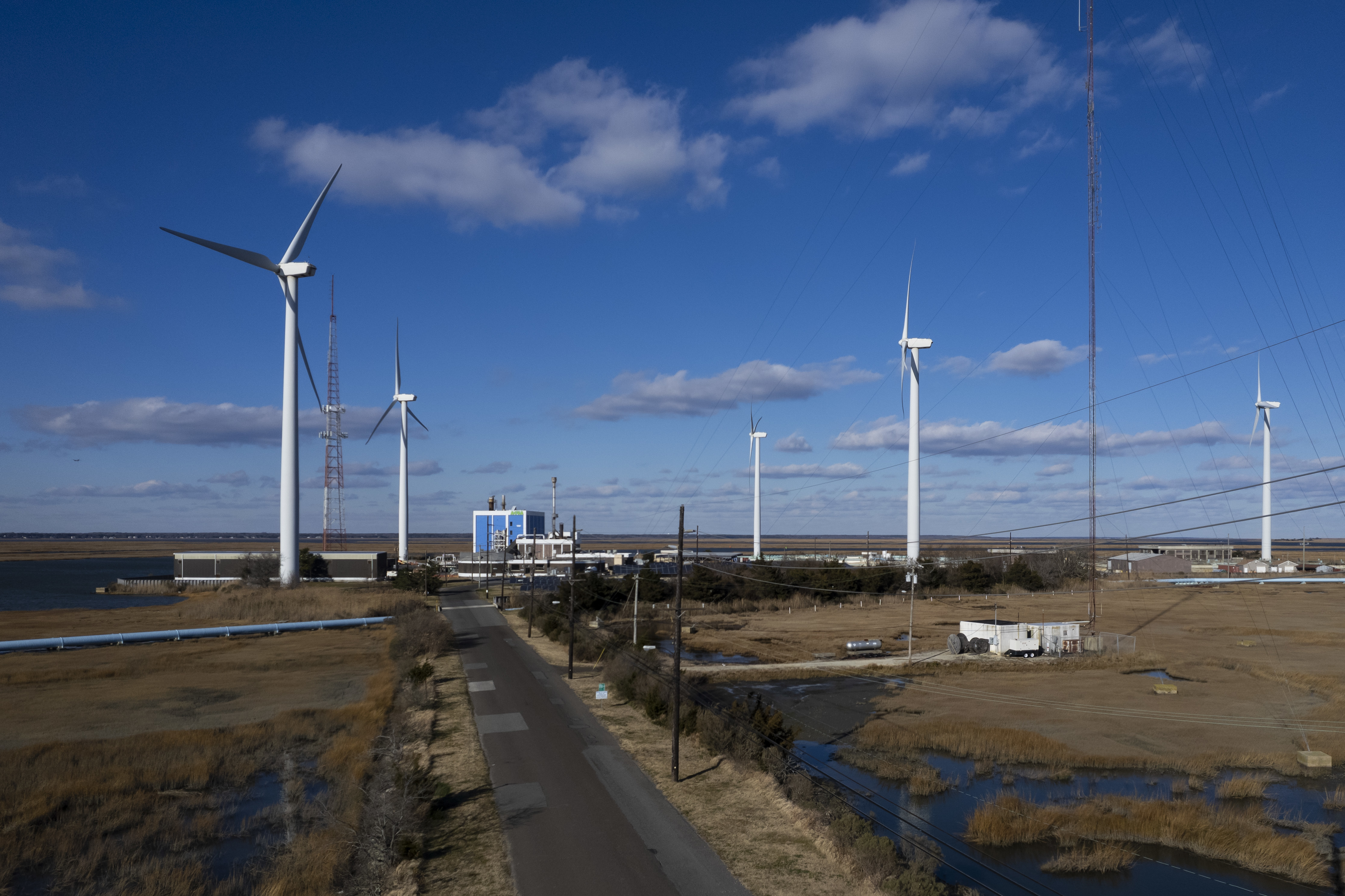
Blustery winds propelled the giant blades of five turbines at the Jersey-Atlantic Wind Farmon a recent day. Set on a back bay island, they were once contested over fears of noise, aesthetics, and worries of threats to Shore birds.
But two decades later, they have emerged as a spinning landmark to Atlantic City.
The 380-foot turbines silently rotate in clear view of motorists streaming to casinos. Some visitors have even requested hotel rooms facing the structures, which are taller than the Statue of Liberty.
The embrace of the land-based wind farm contrasts sharply with the more recently divisive battle over offshore wind projects, an effort stalled by economics and the Trump administration.
Together, the Jersey-Atlantic Wind Farm turbines produce 63% of the energy for the Atlantic County Utilities Authority’s wastewater treatment plant, which serves 14 municipalities. Officials calculate the farm has saved ratepayers $8.8 million since its grand opening on Dec. 12, 2005.
It is one of only two wind farms operating in New Jersey. The other is a much smaller farm in Bayonne.
“This was a total home run for everybody involved,” said Richard Dovey, president of the ACUA at the time it was built. “It’s been nothing but successful, environmentally and economically … [an] inspiration for many other entities, whether they’re public or private.”
How the wind farm came to be
The idea for a wind farm near Atlantic City came from a worker in the energy industry who passed the idea onto Dovey in the early 2000s. With Dovey’s help, it picked up support in former Gov. Jim McGreevey’s administration.
Dovey believed in renewable energy and thought it could power the ACUA’s regional wastewater treatment plant on City Island in Absecon Bay, about two miles from the Atlantic Ocean. He thought Atlantic City’s ample breezes from land and seawould make it an ideal location.
Atlantic City’s ample breezes from land and sea made an ideal location for a wind farm.
Community Energy Inc., a developer of wind power based in the Philadelphia suburbs, played a significant role in the project’s development and received a $1.7 million grant from the New Jersey Board of Public Utilities.
The New Jersey Sierra Club backed the project.
Construction began in mid-2005. The project cost $12 million and included driving pilings into an island of upland surrounded by wetlands and installing intricate concrete bases to support the turbines made by GE.
Currently, the wind farm is owned by Texas-based Leeward Energy. Leeward rents the land for the wind farm from ACUA.
In return, ACUA has a 20-year agreement to purchase the power produced by the turbines from Leeward for 7.9 cents a kilowatt-hour, which was cheap even then. Now, the rate is about half the market rate for energy.
It has helped ACUA keep some of the lowest sewer rates in the state.
However, that agreement is expiring, and the two sides are in negotiations to renew a contract, which could change the rate the ACUA pays for its wind power.
window.addEventListener(“message”,function(a){if(void 0!==a.data[“datawrapper-height”]){var e=document.querySelectorAll(“iframe”);for(var t in a.data[“datawrapper-height”])for(var r,i=0;r=e[i];i++)if(r.contentWindow===a.source){var d=a.data[“datawrapper-height”][t]+”px”;r.style.height=d}}});
Community concerns
Initially, the wind farm faced resistance. Residents in the neighboring Venice Park section of Atlantic City were concerned primarily about potential noise from the turbines.
To allay their fears, Dovey organized a bus trip that took residents to visit a wind farm in Somerset County in Pennsylvania.
“Their major concern was noise,” Dovey, now 73, recalls. “We drove literally underneath the turbine. One neighborhood leader took one step out and said my air conditioner is louder than this; let’s go home. They thought the turbines were beautiful, even inspiring.”
In addition, there were apprehensions regarding how the turbines would affect birds and marine life. The wind farm is just below the Edwin B. Forsythe National Wildlife Refuge, a 48,000-acre area of coastal habitat. New Jersey Audubon agreed to monitor the impact on the bird population as part of its support for the project.
According to the ACUA, a three-year study by NJ Audubon found “a small number of bird deaths which could be attributed to collisions with turbines.” It found more fatalities were caused by raccoons, feral cats, and collisions with wires and trucks.
People were also concerned about the visual impact, fearing they might spoil scenic views, affect property taxes, and hurt tourism. However, the wind farm has since become an iconic part of the landscape.
The concerns were part of a broader debate at the time regarding the emerging push among some New Jersey leaders for offshore wind farms, which had faced a moratorium by the state.
Even though the moratorium was lifted, and Gov. Phil Murphy backed a large offshore wind program that would have powered millions of homes, the debate continued. This year, President Donald Trump issued an executive order to stop offshore wind, making any project in the near future unlikely.
However, a federal judge recently ruled that Trump exceeded his authority with the order, a ruling the administration is likely to challenge. It is unclear whether renewable energy companies still have the political will for a renewed push to build an offshore wind farm off the coast of New Jersey.
Taking advantage of wind
The Jersey-Atlantic Wind Farm is an example of how wind power can work, even if on a smaller scale. The farm is ideally located because of consistent land and ocean breezes. If winds exceed 45 mph, the turbines, each equipped with a weather station, switch off to protect the machinery. That happens only a few times a year.
Matt DeNafo, current president of the ACUA, says the wind farm has been a “huge project” for his organization. The ACUA is operating a pilot project that would store energy captured by the turbines in a battery. A solar array on site also provides about 3% of the facility’s power.
DeNafo said the arrangement with Leeward brought significant economic stability through the 20-year fixed rate. He said it allows the agency to offer the lowest wastewater rates in the region.
At the same time, the ACUA does not have to pay for maintenance of the turbines, while still collecting rent from Leeward.
If winds exceed 45 mph, the turbines, each equipped with a weather station, switch off to protect the machinery.
“It’s really been a great partnership for us. It’s been a beacon for our organization,” DeNafo said. One casino was “getting a lot of requests for windmill-view rooms because it’s got a calming effect.”
Harrah’s, MGM, and Borgata casino hotels all are in view of the windmills.
Amy Menzel, a spokesperson for the ACUA, said summer tours of the wind farm and treatment plant are popular.
“We give open house tours in the summer on Wednesdays,” Menzel said. “People can just drop in. We have a lot of curious people who are visiting the Shore. The tours are really a mix of locals and out-of-town visitors, people who just want to get a little closer and learn more.”
Editor’s note: This article has been corrected to note that the wind farm is on an upland, not a wetland.