Category: Weather

  • Philly gets another ‘trace,’ but snow threat fizzles

    Philly gets another ‘trace,’ but snow threat fizzles

    Wilmington received its first measurable snow of the season — a mighty 0.4 inches — and snow coated roads in parts of southern Chester County Friday.

    But Philly once again had to settle for a “trace,” as the flakes that appeared at Philadelphia International Airport failed to meet the minimum requirements for a snowfall — a tenth of an inch.

    Yes, PennDot was aware of the potential flake invasion, and crews and trucks were on standby, said spokesperson Krys Johnson. But evidently they can save that salt for another day.

    It is possible that the city may see a few flurries this evening, or perhaps freezing rain, said Eric Hoeflich, meteorologist at the National Weather Service in Mount Holly.

    But you aren’t going to pull a back muscle shoveling. Philadelphia stayed to the north of the snow line as the dry, cold air refused to give it up.

    Snow in early December does happen around here, but lack of it is the norm. The “normal” value for snowfall through a Dec. 5 is 0.4 inches at PHL.

    Philly’s snow season typically peaks in late January into February as the prime moisture source — the Atlantic Ocean — has a chance to chill, and the cold air in the upper atmosphere ripens.

    It’s certainly cold enough for snow. Lows overnight fell into the 20s, officially 25 degrees at PHL. Mount Pocono set a Dec. 5 record with a reading of 4 below zero. That’s Fahrenheit.

    Temperatures may not get above freezing Friday, and no higher than the low 40s Saturday and Sunday, which would be several degrees below the long-term daily averages. Another cold front is due Sunday, and readings likely won’t get out of the 30s on Monday and Tuesday.

    No further flake sightings are expected.

  • Philly gets its first winter storm of the season, but hold the shovels

    Philly gets its first winter storm of the season, but hold the shovels

    The region is experiencing a classic Philadelphia early winter storm — a touch of ice and snow, rinsed away by plenty of ice water.

    Some light freezing rain, sleet, and random snowflakes were reported across the region around daybreak Tuesday, and several school districts in Chester and Montgomery Counties opted for two-hour delays.

    Small accumulations of freezing rain, under a tenth of an inch, were measured in the Doylestown and Pottstown areas.

    For the record, the National Weather Service in Mount Holly reported that the city recorded its second official “trace” of snow, defined as a trained spotter’s sighting at least one flake at Philadelphia International Airport.

    That duly noted, Philly’s chances for its first measurable snowfall of the season remained minimal or less.

    “It’s cut and dried,” said Tyler Roys, senior meteorologist with AccuWeather Inc.

    Quite wet, actually. As temperatures rise quickly above freezing, plain, old liquid rain, possibly heavy at times, is expected to persist into the afternoon throughout the region.

    PennDot anti-icing crews have been mobilized, said spokesperson Krys Johnson, but they are also clearing leaf-clogged drains to mitigate road flooding.

    The precipitation should shut off well before the peak afternoon commuting period. However, it appears that the meteorological winter, which began officially Monday, is going to get off to a livelier start than last year’s.

    “We’re changing the script already,” said Roys, noting another storm threat later in the week. “It’s definitely an active start.”

    NOAA’s Climate Prediction Center has the odds favoring below-normal temperatures and above-normal precipitation in the Northeast in the Dec. 7 through 15 period.

    What time will any snow and ice change to rain?

    The changeover to rain should proceed quickly, forecasters say, and it should be raining everywhere by midmorning.

    Winds are from the east, and that is importing warm air off the ocean, where sea-surfaces temperatures off Atlantic City were in the upper 40s on Tuesday morning.

    How much for Philly?

    For Philly, Johnson’s reading of the forecast — “A chance of one snowflake” — was essentially correct. In fact, from King of Prussia eastward, said Roys, “You’re looking at nothing.”

    What is the outlook for the rest of the week?

    The weather community divides the seasons into tidy three-month increments, with Dec. 1 as opening day for winter.

    It will feel that way, with temperatures several degrees below normal into the weekend, with daytime highs Tuesday and Wednesday mostly in the 30s and lows in the 20s.

    A wild card would be the arrival of an Arctic front Thursday morning, said Roys, which might set off snow squalls in parts of the region.

    Another winter storm is possible on the weekend, however computer guidance has been showing just about everything and not much, said Zach Cooper, a weather service meteorologist in the Mount Holly office.

    Welcome to winter in Philly.

  • The season’s first bout of winter weather is possible in Philly early this week

    The season’s first bout of winter weather is possible in Philly early this week

    Philadelphia could experience the season’s first significant blast of winter weather early this week.

    A brewing winter storm may bring a mix of rain and snow to Philly, Trenton, and Wilmington early Tuesday, impacting the morning rush hour, forecasters at the National Weather Service in Mount Holly said. Up to an inch of snowfall is possible.

    Meanwhile, the southern Poconos and northwest New Jersey could see anywhere from 4 to 8 inches of snow. The weather service has issued a winter storm watch for Carbon and Monroe Counties in Pennsylvania and Sussex County in New Jersey.

    Any snow in Philly could quickly change to rain by mid-morning Tuesday, with high temperatures in the low 40s. More than an inch of rain is possible but flooding is not expected, according to Sunday evening’s forecast. Along the coast, 5- to 8-foot seas and gusty winds are possible Tuesday night.

    Sunny conditions are expected Wednesday.

    Over the last five winters, an average of only 11.3 inches of snow per season has been measured in Philadelphia, which is half the long-term yearly average.

    <iframe title="Winters With the Most and Least Snow in Philly" aria-label="Bar Chart" id="datawrapper-chart-aru6W" src="https://datawrapper.dwcdn.net/aru6W/2/" scrolling="no" frameborder="0" style="width: 0; min-width: 100% !important; border: none;" height="628" data-external="1"></iframe><script type="text/javascript">window.addEventListener("message",function(a){if(void 0!==a.data["datawrapper-height"]){var e=document.querySelectorAll("iframe");for(var t in a.data["datawrapper-height"])for(var r,i=0;r=e[i];i++)if(r.contentWindow===a.source){var d=a.data["datawrapper-height"][t]+"px";r.style.height=d}}});</script>

    In more than a century of recordkeeping, half of the top 10 snow years have occurred in the last three decades. And periods of snow lulls are not uncommon, either: In the five winters ending 1931-32, the average was 10.1 inches, and in the five seasons that ended with the winter of 1952-53, the average was 11.8 inches.

  • Some of Earth’s most extreme cold may be headed for the U.S. in December

    Some of Earth’s most extreme cold may be headed for the U.S. in December

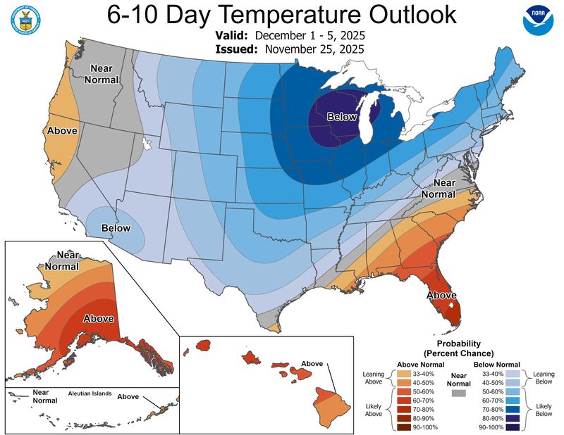
    Meteorologists don’t have the specific forecast ready yet, but there is a growing consensus that December will be a frigid one for parts of the United States.

    The National Weather Service’s Climate Prediction Center says colder-than-normal weather is most likely in the northern and northeastern United States, but some forecasters say a complex dance involving the polar vortex could send some of Earth’s most extreme cold toward the United States.

    “My thinking is that the cold the first week of December is the appetizer and the main course will be in mid-December,” said climatologist Judah Cohen, a research scientist at MIT, in an email to USA TODAY.

    Unusually cold temperatures are expected for most of the north-central U.S. by the first week of December.

    Indeed, according to Cohen’s computer model, “which I can credibly claim as the world’s best — is predicting that the most expansive region of most likely extreme cold on Earth stretches from the Canadian Plains to the U.S. East Coast in the 3rd week of December.”

    As for snow, that remains a wild card, as the weather systems that produce snow typically can’t be predicted more than a few days in advance. Suffice it to say that having cold air present is half of the battle.

    Polar vortex on hold?

    The main “polar vortex” load of very cold air will remain mostly locked up in Canada through the next 7-10 days, said Weather Trader meteorologist Ryan Maue in a Substack post. Maue continues to monitor the polar vortex intrusion risk into the Lower 48 into December.

    Indeed, the complex dances of large-scale climate patterns far above our heads — which include the infamous polar vortex and a phenomenon known as “sudden stratospheric warming” — will determine the intensity and duration of the cold weather in the United States in December, Cohen said. But “I am conflicted about exactly what is happening with the polar vortex,” he admitted.

    How cold will it get?

    Although the most extreme cold won’t arrive until later in December, widespread and persistent below-average temperatures for this time of year can be expected for a wide expanse of the country from the western High Plains to the East Coast next week, with some near average conditions for the Southeast states and warmer over Florida, according to the National Weather Service.

    The coldest anomalies for both highs and lows are forecast over the Midwest Monday Dec. 1 and Tuesday Dec. 2, with highs only in the 10s to middle 20s for many of these areas, and lows in the 0s getting down to northern Missouri and Illinois by Monday morning as the arctic airmass becomes established over the region.

    Some subzero overnight lows are well within the realm of possibility from eastern Montana to North Dakota, the weather service said.

  • Rainy weather is coming ahead of a cold, windy Thanksgiving

    Rainy weather is coming ahead of a cold, windy Thanksgiving

    If you’re heading to grandma’s house ahead of Thanksgiving this week, you might want to pack an umbrella — but other than that, it looks like relatively smooth sailing for Turkey Day.

    Forecasters at the National Weather Service station in Mount Holly predict a period of rainy weather ahead of the holiday, with a warm, wet Tuesday and Wednesday giving way to a dry, breezy Thursday. The weekend, meanwhile, looks to be colder, with some potential rainfall Sunday, but no severe weather appears to be on tap, weather service meteorologist Nick Guzzo said.

    “It looks to be just some rain and a possible isolated rumble of thunder,” Guzzo said.

    Showers are expected to arrive in the Philadelphia region Tuesday afternoon, bringing periodic bouts of rain that will stick around through Wednesday, producing around a half-inch of rain, the weather service estimates. Forecasters do not expect any severe weather, but local rainfall totals could hit up to an inch in some areas, and some thunder in the morning is possible.

    Along with the wet weather comes a warm front resulting in milder temperatures likely nearing 60 degrees that will continue through Wednesday evening.

    By late Wednesday, forecasters predict, a cold front is likely to move in, dropping temperatures and drying out the rain. By Thanksgiving morning, high temperatures are expected to reach only the 40s, with breezy weather throughout the day that will likely bring wind chills in the 30s.

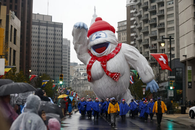
    Thursday’s windy weather could bring gusts around 30 mph, Guzzo said. Representatives for Philadelphia’s Thanksgiving Day parade said they were keeping a close eye on the weather and anticipate the balloons will fly.

    “But should the weather not cooperate, we have contingency plans in place,” said Mike Monsell, spokesperson for parade sponsor 6abc.

    Balloons in Philly’s Thanksgiving parade were last grounded due to high winds in 2019 — though wind gusts that year reached high speeds of up to 50 mph. Before that, the parade’s balloons had not been grounded since 1997, when similarly high winds kicked up on Thanksgiving Day.

    Friday and Saturday are expected to bring a preview of winter weather with morning lows in the upper 20s — roughly 4 to 6 degrees below average for this time of year. That is thanks to the cold front moving through the area, Guzzo said, which will keep highs in the low to mid-40s.

    As for weekend rain, Saturday looks dry, but as milder conditions take hold, there is a slight chance of rain Sunday to close out the weekend.

  • No, it’s not going to snow on Thanksgiving in Philly, but a taste of winter is coming

    No, it’s not going to snow on Thanksgiving in Philly, but a taste of winter is coming

    The snow rumors notwithstanding, the Philadelphia region and most of the rest of the Northeast can pretty well rule out a white Thanksgiving, nor will Black Friday turn white.

    However, the upper atmosphere evidently is in a state of upheaval with a potentially rare event unfolding, and forecasters say something resembling winter may arrive around here before the holiday weekend ends.

    The National Oceanic and Atmospheric Administration’s Climate Prediction Center has chances favoring below-normal temperatures and above-normal precipitation from Thanksgiving Day through Dec. 1.

    However, the meteorologists who have grappled with longer-range outlooks are cautioning against taking social media snow forecasting too seriously.

    “The observed snowfall is inversely proportional to the hype,” said Judah Cohen, research scientist with the Massachusetts Institute of Technology. He is among those who have noticed the snow mentions that have popped up on X accounts and popular websites.

    The next week should generally be uneventful save for rain Tuesday night possibly into getaway Wednesday, when highs are forecast to reach the 60s.

    Then a developing pattern change is predicted to import colder air into the Northeast. “I do believe it will get colder as the Thanksgiving week wears on,” said Bob Larson, senior meteorologist with AccuWeather Inc.

    A rare event may chill December

    What has the attention of Cohen and others in the meteorological world is the potential for a “major” stratospheric warming event in the upper atmosphere over the Arctic sometime in the next several days, a disruption that could allow significant cold air to pour into the United States.

    Major events have occurred on average about six times a decade, according to NOAA researchers; however, having one so early would be a rarity.

    If one occurred, it would be only the second time in records dating to the early 1950s that it has happened this early, said NOAA meteorologist Laura M. Ciasto.

    While computer models have been debating over just what is going to happen, Cohen, chief of seasonal forecasting for the Janus Research Group, said that such an early date has given him pause about forecasting it will happen.

    What causes a stratospheric warming event?

    On occasion, upward-moving waves from the troposphere, 5 to 9 miles over the Arctic, crash into the stratosphere, 10 to 30 miles up. That has the effect of compromising the polar vortex, the west-to-east winds that lock cold air in the places where the sun disappears for the winter, Ciasto said.

    When the winds slacken, the vortex can weaken and allow frigid air to spill southward. In some cases it might “stretch,” or split into pieces that deliver cold air to regions of the Northern Hemisphere.

    A major disruption would have longer-lasting impacts, Cohen said.

    The European forecast model has consistently predicted a major event, Ciasto said, while the U.S. model has not been as impressed.

    What is likely to happen if the warming event occurs?

    A major warming in January 2021, when temperatures in the stratosphere suddenly jumped 65 degrees Fahrenheit, resulted in quite a snowy February in the Philadelphia region.

    After a warming event, “there’s a greater chance that the jet stream will become more disrupted and dip down” over the continuous United States, Ciasto said, “bringing cold air with it.”

    As for timing, the effects may show up anywhere from two to several weeks after the event.

    In the meantime, she noted that “several other factors,” including patterns over the North Pacific, favor a chilling for the Northeast.

    Don’t be surprised to see snow appear in an actual forecast, but not necessarily on the ground.

  • What to expect for the Philadelphia Marathon weekend weather forecast

    What to expect for the Philadelphia Marathon weekend weather forecast

    Assuming the sports scientists have it right, the temperatures should be near the performance sweet spots for the runners participating in the Philadelphia Marathon Weekend races on both Saturday and Sunday morning.

    At showtimes, 6:55 a.m., just moments after daybreak, temperatures Saturday are expected to be in the upper 40s to near 50 degrees for the half-marathoners, and in the upper 30s to around 40 for Sunday’s main event.

    Light rain is expected through the early-morning hours Saturday, and forecasters have been on the fence about when it will shut off. Nick Guzzo, a meteorologist at the National Weather Service said Friday afternoon that rain was likely at the start of the race, but that probabilities would drop precipitously once the event was underway.

    AccuWeather Inc. and weather.com were posting about a 50-50 shot that the rain would continue through the morning. The hedging isn’t surprising; timing the onset and end of precipitation has been a longstanding forecast problem.

    Nor would it be surprising for those running the 13.1-mile race to experience conditions different from those logging 26.2 miles the following day, points out Kathleen Titus, the race director and runner who has been involved with the marathon for 20 years.

    This time of year is a busy one for frontal passages, this being a transition period when the atmosphere isn’t quite sure what season it wants to be. The temperature has reached 74 degrees on Nov. 22 (1883), and plunged to 14 (1880), and snowed 4.6 inches on Nov. 22-23, 1989.

    However, nothing momentous is expected this weekend.

    Like the rains, winds are forecast to be light, under 10 mph, from the north on Saturday, and northwest on Sunday, although runners allow that on the course, the wind can be way more capricious than the temperatures.

    Why runners like these temperatures

    Various studies have concluded that temperature is the most important weather variable in runner performance and that the ideal range for marathoning is 39 to 50 degrees Fahrenheit — give or take a few degrees.

    “Your body is always competing between a couple of different things,” said Philip Skiba, sports medicine specialist at Thomas Jefferson University Hospital, who helped train Eliud Kipchoge, the Kenyan who became the world’s first runner to complete a marathon in under two hours.

    During exercise, muscles demand blood to work, while for the body to stay cool, blood has to flow to the skin. If it’s too hot, more blood flows to the skin. When it’s cold, blood is diverted to heat the body’s core.

    With temperates in that 39-to-50 range, the blood flow can more easily serve both the muscles and skin. Said Titus, racers love that temperature range because, “It regulates your body. It just works.”

    Skiba said the temperature ranged from 51 to 55 degrees on the October 2019 day Kipchoge broke the two-hour barrier in a Vienna event that wasn’t held under record-eligible conditions.

    Had the temperatures been lower, Kipchoge could have shaved a few more seconds off his time, Skiba said.

    The wind also is a player in marathons

    While not as dominant as temperature, “wind resistance … is worth a few seconds per mile,” said Skiba, a former triathlete.

    “The more you stay out of the wind, you can save considerable energy,” he said.

    “It’s really important to learn how to draft,” that is, get behind a group running close to your pace and using them for wind-breakers, he said. (Not sure how the wind-breakers feel about that.)

    On the Philly course, the winds can be wild cards, especially on Kelly Drive, Titus said.

    One instant, the wind “hits in your face. Now it’s at my back!”

    Titus said she actually likes running uphill into the wind — and she is believed to be a member of a distinct minority — but agrees that “it is nice to have it at your back when you’re coming into the home stretch. Because it does give you a little boost.”

    The Philly Marathon is holding out hope for a record

    Titus said she is hoping for a record this year, unrelated to race times.

    She encourages people to overdress to stay warm before the running gets underway, and to be liberal about peeling off layers during the race.

    The shed garments are collected and given to the Salvation Army.

    “We’d love to break some record in the clothing donation,” she said.

  • A storm looms in what’s going to be another rough week for Jersey beaches

    A storm looms in what’s going to be another rough week for Jersey beaches

    New Jersey’s beaches, still recovering from major sand losses from an offshore hurricane and a nor’easter, evidently are in for another assault this week as October is about to make a dramatic exit.

    Gale-force gusts off the ocean could develop as early as Tuesday afternoon at the Shore, said Eric Hoeflich, a meteorologist at the National Weather Service office in Mount Holly, with brisk onshore winds persisting “maybe into Friday.”

    A potent storm is forecast to affect the entire region Wednesday night into Thursday, with heavy rains in the immediate Philadelphia area, where drought conditions have been intensifying.

    Also on Thursday, what is likely to become catastrophic Hurricane Melissa will be passing offshore, churning up the waves crashing on East Coast beaches.

    “The coast once again is going to take a pretty good battering,” said Dave Dombek, senior meteorologist with AccuWeather Inc.

    On the plus side, Hoeflich said, for the Shore, this week’s storm “doesn’t look as bad” as the beach-erasing nor’easter earlier this month. The path should be more inland, and the lunar influence on the tides would be less. Only minor flooding is expected, he said, subject to change.

    However, not only would the track mean region-wide heavy rain, but it would also increase the potential for severe thunderstorms Thursday. A front is due to chase the rains Friday, but it may generate gusts to 50 mph, the weather service says. Power outages are possible both days.

    The timetable for the winds and the storm in the Philly region

    The National Weather Service has posted a gale warning for Tuesday into Wednesday morning for the waters along the immediate coast for winds from the east that could gust past 50 mph.

    That would be more the result of high pressure to the north of the region. Winds circulate clockwise around centers of highs; thus, areas to the south of the center experience winds from the east.

    The breezes will be getting a second wind as a storm develops in the Southeast and tracks north. Meanwhile, a weakened Hurricane Melissa will be churning the ocean as it passes well off the U.S. coast on Thursday.

    The Philly region could use the rain

    The interagency U.S. drought monitor has the majority of the region in its “moderate drought” category.

    Rain for the last 30 days has been about a third of normal in the city and the neighboring Pennsylvania counties.

    South Jersey has fared only slightly better, but precipitation is well less than half of normal.

    What is the forecast for the trick-or-treaters?

    It is all but certain that Friday will be a dry day, with temperatures in the low and mid-50s. Wind gusts are forecast to die down sometime after 5 p.m., but hold onto those brooms, just in case.

  • Frost advisories are posted as Philly has its chilliest spell in six months

    Frost advisories are posted as Philly has its chilliest spell in six months

    Frost advisories are up for Friday morning for areas just outside Philadelphia on both sides of the Delaware River as the region is about to experience its chilliest spell in more than six months.

    While the urban hotplate areas of Philly and Delaware County were not included in the National Weather Service advisory zones, cooler areas of the city and Delco could see some patchy white.

    “It is certainly possible,” said Zachary Cooper, a meteorologist at the agency’s Mount Holly office.

    Conditions conducive to frost — relatively clear skies, temperatures in the 30s, and light winds — may whiten the pumpkins in the region through the weekend.

    As per standard procedure, the weather service will be issuing frost advisories until the end of the growing season, defined as the first time temperatures reach 32 degrees or lower in a given area.

    It won’t be freezing, just frosty

    Philly’s first freezing reading typically doesn’t occur until mid-November, but frost can form with temperatures above 32.

    The air temperatures are measured about six feet off the ground, but they can be several degrees lower on the ground and on cooler surfaces.

    When winds are calm, they keep the air from mixing, and that allows thin layers of colder air to develop at ground level.

    The winds won’t be completely calm Friday morning, but “they should be light enough for favorable” frost conditions, the weather service said.

    The dry spell in the Philly region continues

    Temperatures should be several degrees below normal into next week, with highs mostly in the 50s and lows 35 to 40 degrees, the weather service says.

    Notably absent from the extended outlook is precipitation. Officially, at Philadelphia International Airport, only 0.81 inches of rain have fallen this month. That’s less than a third of normal.

    Most of the region is in “moderate drought,” and remaining areas are “abnormally dry,” according to the U.S. Drought Monitor’s Thursday update.

    That could change the middle of next week, as computer models have been hinting at an active pattern.

    However, this should be a splendid weekend to get out and enjoy the burgeoning foliage show.

  • What to know about symptoms and treatment for dehydration and heat exhaustion

    What to know about symptoms and treatment for dehydration and heat exhaustion

    Brace yourselves, Philadelphians. The region’s first prolonged heat wave of the summer is expected to hit in coming days, with temperatures nearing 100 degrees.

    On Friday evening, the city’s Department of Public Health declared a heat emergency beginning Sunday at noon through Wednesday at 8 p.m., though the timeframe may be extended if dangerously high temperatures persist. While the declaration is in effect, the city is expected to open centers where people can go to cool off, among other measures.

    Philadelphia hasn’t seen 100-degree heat in June since 1994, according to the National Weather Service.

    Meteorologists are also predicting oppressive humidity in our region, meaning it will feel even hotter and overnight temperatures will not offer much relief.

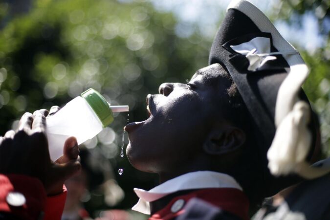
    Staying healthy during the heat wave comes down to two basic things: drinking water and cooling down as much as possible.

    Here is what you need to know about heat-related illnesses:

    What are the signs of dehydration?

    Water serves critical functions in the body, including cooling it down, maintaining blood volume, and balancing electrolytes.

    Dehydration happens when individuals lose more water than they are taking in. Even though it could happen to anyone, dehydration poses a specific risk to children, elderly, and people with chronic illnesses.

    The signs of dehydration are dark-colored urine, less frequent urination, fatigue, confusion, and dizziness. With babies, parents should monitor diapers to ensure that they are continuing to provide urine.

    Untreated dehydration can contribute to heat exhaustion or heatstroke, reduced blood pressure, fainting, and seizures.

    What are the symptoms of heat exhaustion?

    As the body remains overheated, it will continue to sweat and further lose liquids. If individuals’ skin becomes cold and pale, they complain of dizziness and headaches, and seem tired or weak, these are all signs they might be suffering from heat exhaustion.

    At this stage, consider calling 911 if a person is vomiting, the symptoms get worse, or last longer than one hour.

    What are the symptoms of heatstroke?

    Heatstroke is when the body can no longer regulate its temperature. People may stop sweating and spike a fever. The cold, pale skin could turn hot and red. In addition to the fever, people may be confused, pass out, and vomit.

    If someone is vomiting, unable to drink, or losing consciousness, medical attention is likely needed in an emergency department. Medical staff there can cool the person down and provide intravenous fluids. If you suspect that someone is suffering heatstroke, call 911.

    How to prevent and treat dehydration, heat exhaustion, and heatstroke

    Water is your best friend during the heat wave. As much as possible, keep hydrated. Adequate water intake for adults is about 11 to 15 cups a day. While water is not the only hydrating drink, avoid caffeinated and alcoholic drinks, which can contribute to dehydration.

    Cooling down is also critical. Look for shade, avoid the sun, and when possible, stay inside air-conditioned buildings. This will help the body regulate heat and preserve liquid, especially during the hottest hours of the day in the afternoon.

    There are open splash parks and pools throughout the city where people can go to cool down, though if you spend time in the sun, be sure to put on sunscreen to avoid sunburns.

    For people who are dehydrated, get them to a shaded and cooler area and have them drink water. If at any point they lose consciousness, vomit, or are unable to drink, seek medical attention immediately.

    How to treat heat rash and cramps

    Two other potential unpleasant outcomes of heat are rashes and cramps.

    When sweat is trapped in the skin, a potentially itchy heat rash can appear. It can be in the form of small blisters to larger lumps. Heat rashes usually resolve without treatment when the body cools down. The CDC recommends keeping the rash dry and using baby powder to soothe itchiness. Go see a healthcare provider if the rash doesn’t go away within a few days, gets worse, or if you develop additional symptoms or are concerned that other health issues are involved.

    Heat cramps are involuntary muscle spasms that can occur due to fluid and electrolyte loss, which is common when exercising on a hot day. If you have heat cramps, stop any physical activity, move to a cool place, and drink water. A sports drink with electrolytes can also help.

    Seek medical attention if the heat cramps last longer than an hour or if you have a heart condition.